This post is part of a series of posts and resources on drones and the world of intelligence. For an in-depth look at the U.S. communications infrastructure at the heart of drone operations, click here. For resources on how to find and spot drones, click here. For our Multimedia Portal on drones and intelligence, click here.
By Dan Gettinger
Drones are located at a number of U.S. or partner-operated airfields around the world. By looking at a combination of public sources including satellite imagery, news stories, and military budgets, it is possible to obtain and deduce a great deal of information regarding military drone use. While this guide deals primarily with finding American drones like the Predator, Reaper, and Global Hawk, one can apply these methods to examining the drone activities of other countries such as China, France, and Iran. Here is a step-by-step guide to global drone hunting.
- Where in the world are the drones?
News stories are often a useful place to start looking for drone bases and operations. The Washington Post in particular has reported extensively on covert operations and drone bases. Other media sources include blogs such as the Open Source Imagery and Geospatial Intelligence blog (OSIMINT), Bellingcat, the Arkenstone, and Beattie; these blogs use open-source methods to spot drones around the world and contain libraries of helpful resources that can help you in your search.
Another resource is the Pentagon’s construction budgets. For every fiscal year, each service branch is required to publish a detailed budget for each of its construction projects around the world. Many of these budgets contain explicit requests for funding to build structures that support the operation of unmanned aircraft. In the FY 2016 funding request, the Air Force allocated $50 million for building a drone apron in Agadez, Niger. Of course, not all building projects are listed in these publicly available reports. Funding for some projects is classified; in FY 2005, the Air Force allocated $26.1 million for worldwide facilities for the MQ-1 Predator.
Note: When searching government documents such as military construction budgets, use the term “Remotely Piloted Aircraft (RPA)” or “Unmanned Aircraft/Aerial System UAS” instead of “drone.”

- I’m at a base – now what do I do?
Finding the drones depends on whether you are searching a base within the continental United States or at an overseas station. The location of the base will affect the type of buildings that house the drones and the area of the base where these buildings are placed within the base. For example, within the United States, drones are housed in large, steel-frame hangars, while overseas, hangars are often re-locatable “clamshells” made of rigid fabric. For details on the types of buildings, visit our reference page.
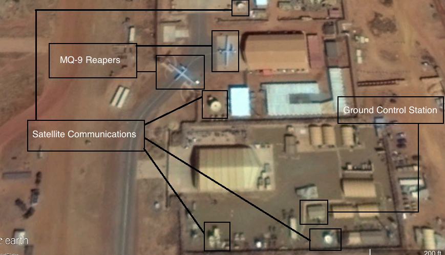
Every part of the base that is navigable by aircraft is attached to the runways by a taxiway that leads to the hangars and aprons that serve as parking and maintenance areas for aircraft. After tracing the taxiways to specific aprons, you can begin to identify the buildings and facilities located in that area. The drone apron is often located near the Ground Control Station(s) where crew members pilot the aircraft. On some bases, particularly partner-operated stations overseas, the drone apron and the attendant support facilities are often physically removed or isolated by a security perimeter from the rest of the airfield. This is the case at Agadez Airport in Niger, for example, where French and American drone operations share the airfield with civilian aircraft.
- There are lots of aircraft pictured here. Which ones are drones?
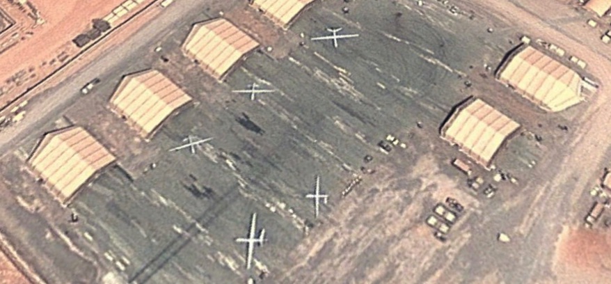
The unique shape of the drone distinguishes it from most military or commercial aircraft you are likely to see in these satellite photos. Unlike most aircraft, the body of the drone is narrow, and its wings are long and straight like a glider. The manned U-2 aircraft is probably the most similar to the drone in its build, but unlike most drones, it is painted black. For more information on the types of aircraft, visit our reference page.
The size of the aircraft will often give away the model. The Reaper is larger than the Predator, and the Global Hawk surpasses the Reaper in size. A Global Hawk typically has white wings and a gray body, making it more recognizable from the air. If you’re unsure, you can use the ruler function in Google Earth to measure the distance between the wingtips of the aircraft. The Predator also has the distinctive tail that looks like “^”, while the Reaper’s tail is an upward V.

- If I can’t spot any drones, what might be some other features of a drone base?
Besides the hangar and the aircraft, other landmarks include the Ground Control Station (GCS) and communications equipment such as satellite dishes. American drones are piloted by two different sets of crews, one set inside the United States and one at a base overseas where drones are located and maintained. Both crews require a Ground Control Station and communications equipment in order to fly the aircraft. From the air, the GCS will just look like a rectangular shipping container. However, unlike shipping containers, which are usually bunched together as closely as possible on the edge of the airfield, the GCS will typically be located on or around the drone apron and close to communications equipment. GCS’ are also quite small—around 25 ft. long—and sometimes the GCS itself will have exterior distinguishing features like an air conditioning unit or communication towers. When searching an overseas station, areas with an added level of security such as a perimeter wall could indicate drone activity. Remember to look for areas that combine structures—hangars, communications equipment, and the Ground Control Station.
- I know there should be a drone here, but I can’t find it. What do I do?
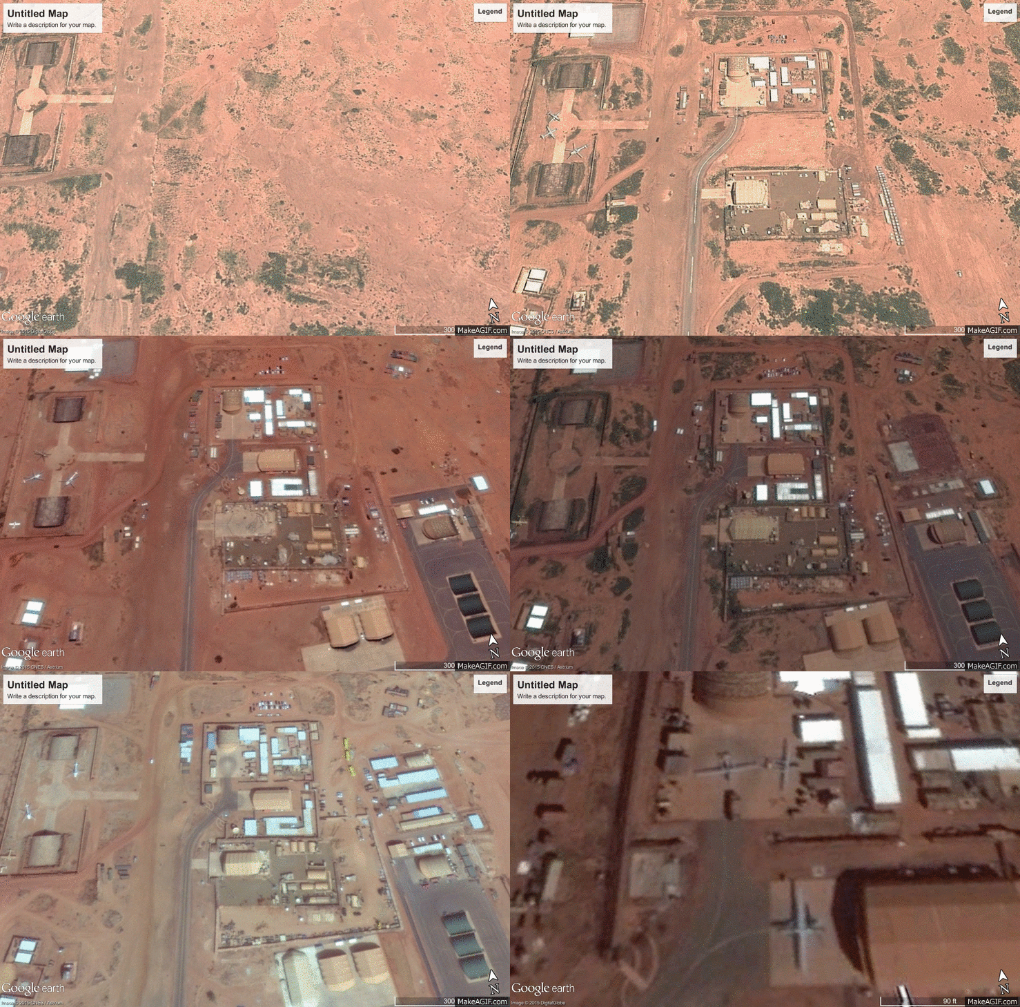
Catching a UAV out in the open—and not in a hangar or in the air—is not always easy. One of the most useful tools that Google Earth has it offer is the time scale. Google Earth compiles satellite imagery from different sources that were taken at different times. Some parts of the world may have imagery from January 2015, while others date from earlier years. Using the time scale tool, you can cycle back through the years of available imagery for that area. For example, while the latest images of a joint American-French drone operation in Niamey, Niger don’t show any drones, a compilation of the imagery from previous months and years reveals not only drones, but the growth of operations at that base.


